


Refuge du Pigeonnier par vaccivier Lac bleu et lac Lauzon

Surfou
User
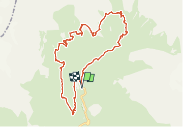

Length
13.1 km

Max alt
2450 m

Uphill gradient
1009 m
Km-Effort
27 km

Min alt
1634 m

Downhill gradient
1004 m
Boucle
Yes
Creation date :
2022-08-12 07:02:21.066
Updated on :
2022-08-12 13:39:06.578
4h31
Difficulty : Very difficult

FREE GPS app for hiking
 SityTrail
IGN / Geographical institutes
SityTrail Plus
The world is yours!
About
Trail Walking of 13.1 km to be discovered at Provence-Alpes-Côte d'Azur, Hautes-Alpes, La Chapelle-en-Valgaudémar. This trail is proposed by Surfou.
Positioning
Country:
France
Region :
Provence-Alpes-Côte d'Azur
Department/Province :
Hautes-Alpes
Municipality :
La Chapelle-en-Valgaudémar
Location:
Unknown
Start:(Dec)
Start:(UTM)
285116 ; 4968944 (32T) N.
Comments